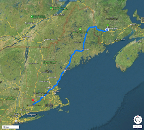
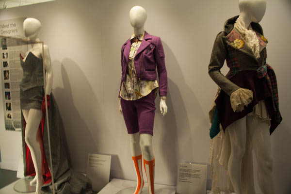
A few months ago, I had heard that one of my favourite UK actresses, Nicola Walker, was coming to Broadway (along with her fellow theatre cast & crew) to reprise her role in Arthur Miller’s “A View From The Bridge”. I had seen it done via the National Theatre Live performances that our local cinema ran and I was duly impressed, so when the opportunity presented itself, I contacted some friends to see if they were interested in joining me. (More about that post about meeting Nicola Walker over here). Thus began the planning for my fall road trip. I’d bought a new car back in the summer (a red 2015 Hyundai Tucson) and I was itching to really give it a good road trip so this was the start. I kept record of the distances travelled, more for curiosity sake than anything else.
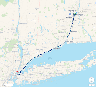
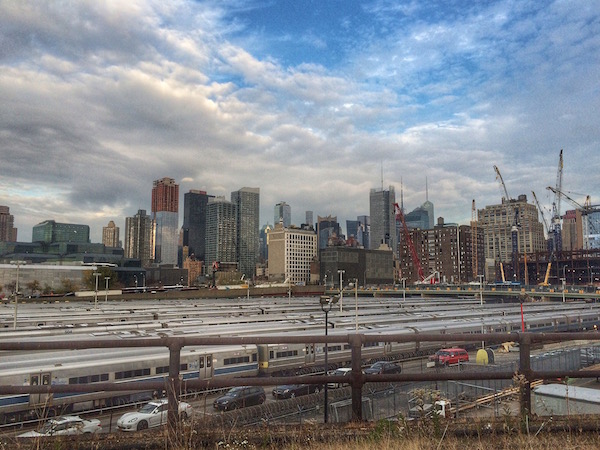
My first part of the journey took me down to Newington, CT to visit my friend, Anna – as she and I were heading to New York together. Across an international border and through four States. A mostly uneventful drive, though was held up in traffic in a couple of spots but got there safe and sound. A lovely meal followed by relaxing evening (and a bit of a late night) getting caught up on two of Nicola’s shows that were currently airing in the UK – “River” and “Unforgotten”. Early morning came and we were getting everything ready to head into New York City by train.
New York was a lot of fun – as it usually is when I visit. We got into Penn Station then went about getting an MTA card for Anna for the subways (the one I had from my February trip was still valid), then we headed down to our hostel, which thankfully was all ready for us, albeit on the top floor of a 3 story walk-up. And NYC was strangely very warm for early November. We met up with another friend (Bettie) and grabbed some lunch at an English fish & chip shop called A Salt and Battery – very yummy! Followed by a nip into the Tea & Sympathy shop next door.
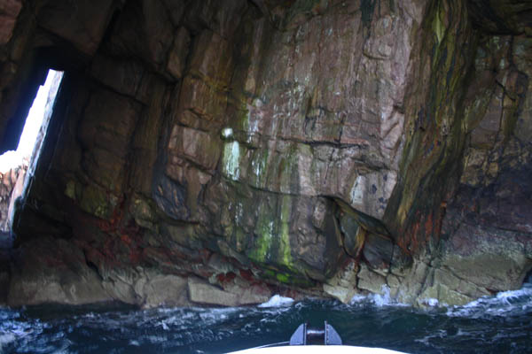
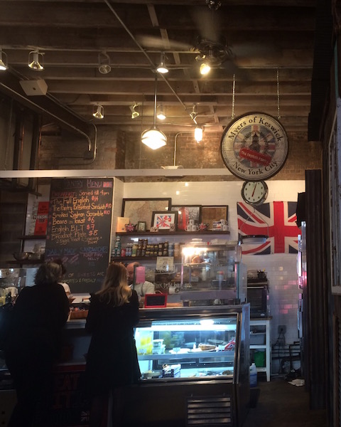
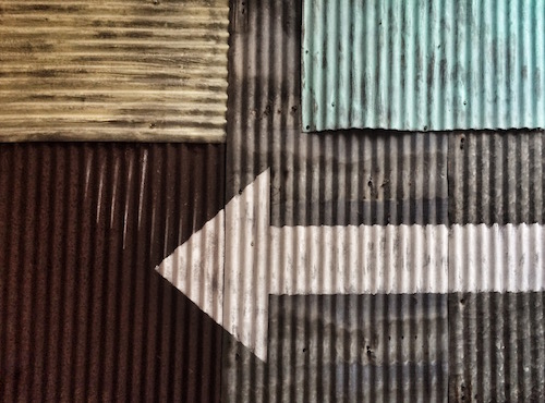
Bettie treated us to a NYC walk through Chelsea through the Meatpacking District where we stopped at the Gansevoort Market for a walkthrough. The photo on the left is of an English deli in the back right of the market, called ‘Myers of Keswick’. Along side the wall as we were leaving I found the corrugated metal wall very interesting so I took a shot.
Following that stop, we headed up to The Highline. If you haven’t yet heard of this, The Highline is a 1.45 mile park that was built upon an abandoned elevated train line that runs from Gansevoort Street and Washington Street up around the rail yards finishing at 34th Street and 11th Avenue. This was my second time on The Highline, the first time was a few summers ago with some friends. The park is a great use of the old train line, with shops, artisans, musicians blending in with the trees and plants. There’s lots to see and check out. When we finished on the Highline, we took the subway (from the new Hudson Yards station, at the start of the 7-line) to get to the next stage of our evening.
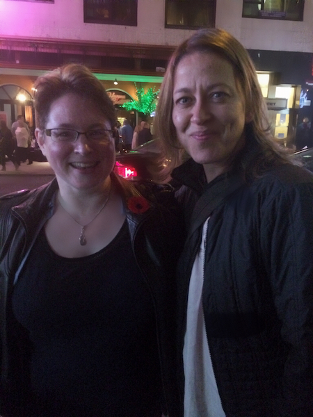
We’d gone to Junior’s for supper then off to the theatre to see Nicola Walker in “A View from the Bridge”. If you have a chance to go see it, do so! It runs until 21st February 2016. After the show, I had the chance to meet some of the cast, including Nicola Walker, which was utterly fantastic!
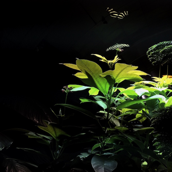
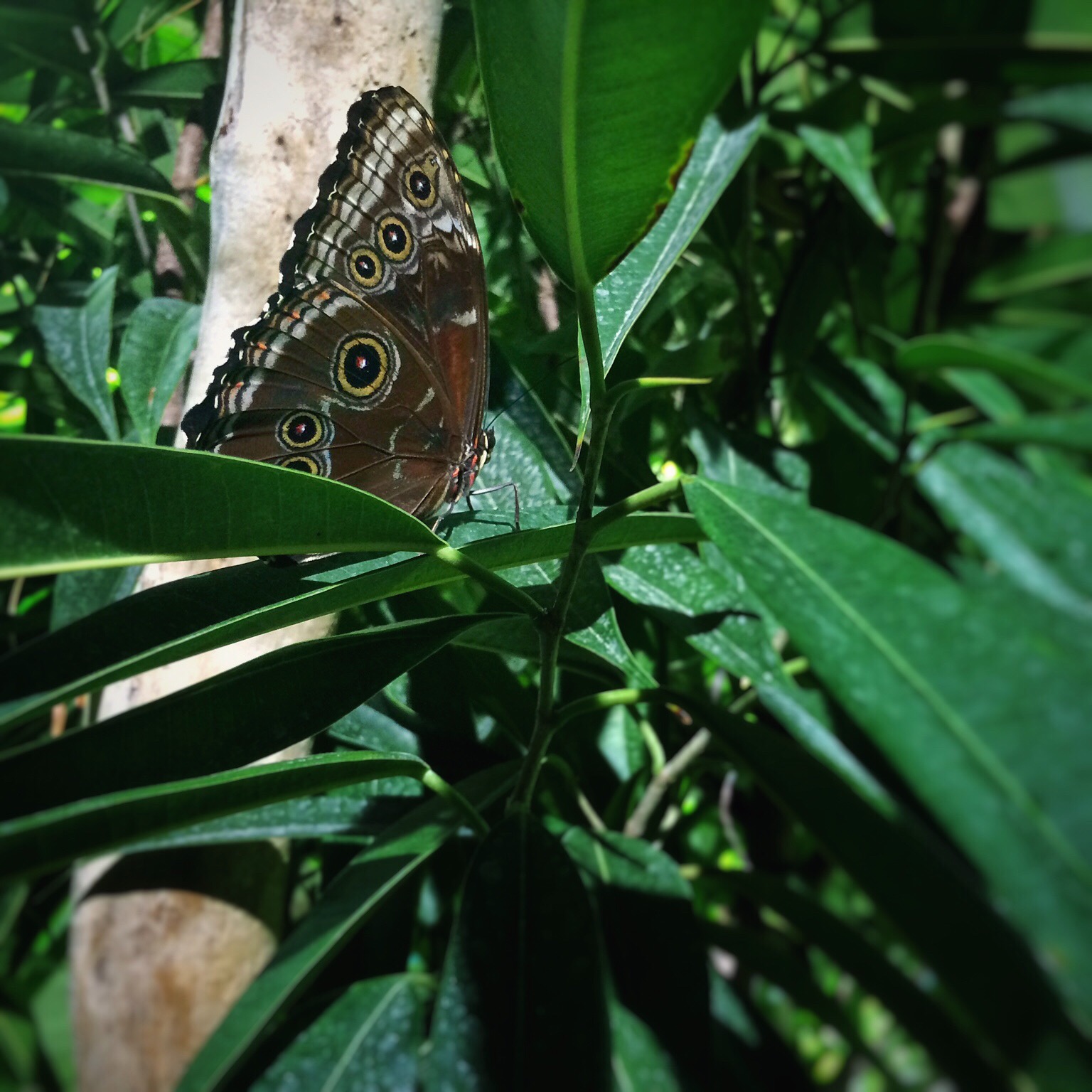
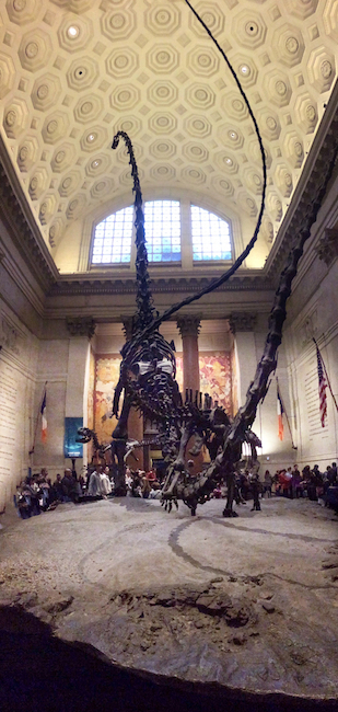
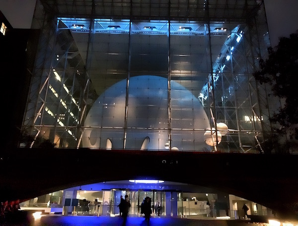
After another stop at Junior’s for cheesecake, we concluded our night back at our hostel, still on a high from the show and the meeting. On Saturday, the 7th November, we had a bit more of a relaxing day, meeting up with friends for a fabulous lunch up at Spring Natural Kitchen (474 Columbus Ave & 83rd Street), then a meander through the American Museum of Natural History. I wanted to see their Butterfly Conservatory, the dinosaur skeleton, and the Hayden Planetarium.
After a rigamarole of trying to get to our hostel via subway via a roundabout run – weekend underground construction work meant some of the trains were only going uptown first then down on another line express. Which meant we had a very quick pitstop down to the hostel to pick up our bags from the lockers, then quickly get Penn Station for our train back to Connecticut.
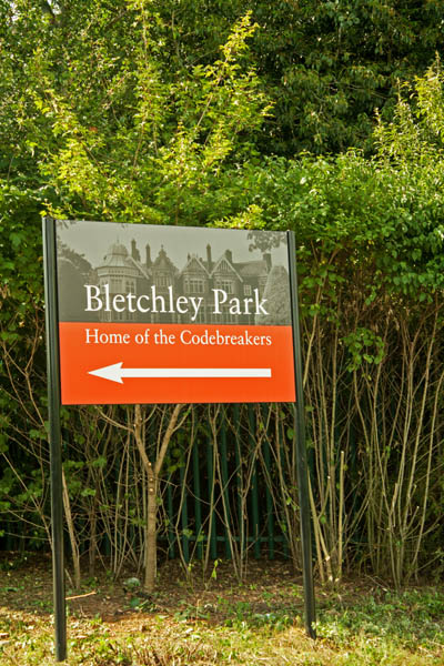
The first time I’d really heard about the Bletchley Park Museum was last fall when Dr. Sue Black was interviewed by Aleks Krotoski on the Guardian Tech Weekly podcast, Sue Black on the campaign to save Bletchley Park. I mean, I probably heard about it in a high school world history class but that’s about twenty plus years ago.
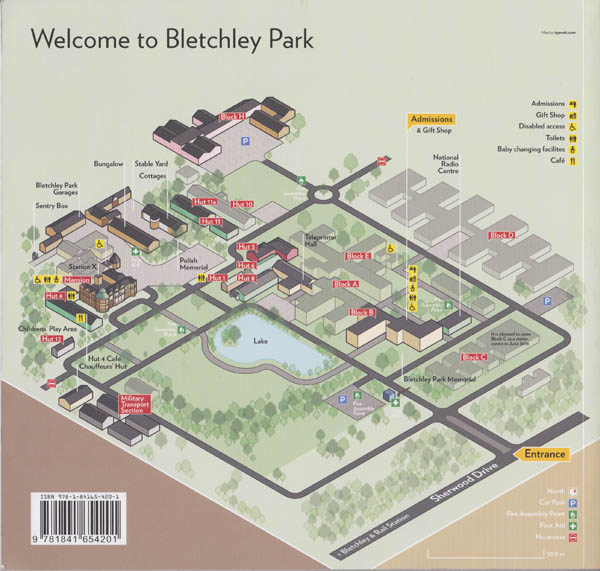
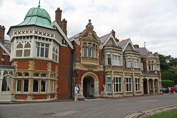
I developed quite an interest in the restoration project and when I knew I was going to the UK, I decided that I was going to make a plan to visit the Museum. I checked with my cousin who was also interested in coming with me so I got us two return train tickets from Epsom to Bletchley Park. On the day of travel to Bletchley, the train from Epsom to Victoria Station was fine but apparently some idiot decided to jump onto the Victoria Line tube tracks during the 9am rush hour period so there was going to be a delay in service. After waiting a few minutes, we decided to take a taxi over to Euston Station to get our connecting National Rail train to Bletchley. The train to Bletchley was fairly relaxing as it was a north-based train off-peak time. The train station is pretty much across the street from the Museum grounds – just up the street a short distance away.
I did pick up a copy of the Bletchley Park Visitor’s Guide as I knew there was going to be so much information presented that I would never remember it all, and I have to admit that my understanding of the complexity of the mathematics coding that went into deciphering the messages is not anywhere near the level of knowledge involved. This is not a history lesson and I know there is plenty of information that will be inadvertedly left out. If you want to know more detailed information, there’s lots of wonderful books out available through the Bletchley Park Museum Store and Amazon.co.uk.
The strategic location for the codebreaking teams of scholars was chosen because it wasn’t in London but also not too far, accessible by train, and on major communications links connectors.
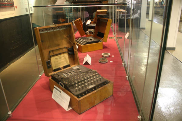
For anyone who doesn’t know, Bletchley Park was the site of the code breaking of the Enigma Code during World War II. The German military (Army, Navy and Air Force) used a more advanced Enigma Cipher machines during World War II to send messages to the field commanders and the High Command, and they consistently believed that throughout the war that these messages would not be able to be deciphered. During war time, the codes were changed daily, giving 159 million million million possible settings to choose from. The Polish initially broke the code in 1932 with intermittent trials, but the Germans had advanced the machines for their military use during wartime. Knowing they were going to be imminently invaded by the Germans, the Polish informed the British in 1939, when they needed help to break the newer designed Enigma cipher machines. The initial break of the German enigma machines came in 1940 under the team lead by Dilly Knox, with the mathematicians John Jeffreys, Peter Twinn and Alan Turing, unravelled the German Army administrative key that became known at Bletchley Park as ‘The Green’ (source: Breaking Enigma).
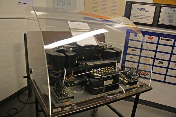
To look at the Engima Cipher machines, there is a typewriter-like Qwerty board (without the symbols). Above those typewriter keys is a panel of three rows with corresponding qwerty buttons. In addition, under the front panel of the Enigma machines was another row of corresponding keys with wires running to different outputs, so one letter would represent another, but not the same letter twice in a row turned up even if you pressed the same letter on the keyboard. The machine’s elements can lead to billions of permutations of possible outcomes. Both the Enigma machine and the deciphering machine had to be set up the exact same way in order to send and receive messages. In addition to figuring out the Enigma coding, the British used an encryption device called the Typex, that was an adaptation of the Enigma machine, with enhancements that increased security.
This video more easily explains what I was trying to say:
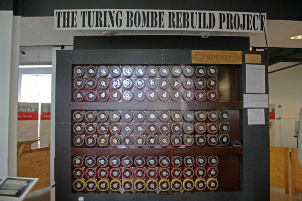
The number of possible permutations was pretty astronomical to be done by hand so British mathemeticians Alan Turing and Gordon Welchman built on the information provided by the Poles and were able to build the Bombe machine that would enable them to more easily decipher the German messages. Once it was determined which letter represented another letter, the mathematicians would look for repeating patterns of words, some found in error. As you can see in the photo below of the Bombe machine, there are three banks of dials, stacked three high in each bank, and 12 rows of dials. Each row of three represented one Enigma machine that would go through the possible choices, and each Bombe machine represented 36 Enigma machines. As the top one rotated so many times, the next one below would move one stop, and once the middle one rotated one full stop the bottom dial would start to turn, until each locked in one letter combination, that was then checked on another machine. The Bombe machines brought the number of possible permutations down to a level where they could be checked by hand and then checked through an interpreter who knew the German language. It was rather fascinating to watch them go through the process with the Turing Bombe Rebuild Project machine. For further information, please visit: Bombe Rebuild Project. Below the image is another video, properly explaining the process of deciphering Enigma with the Bombe machines and working out how letters possibly worked together to form words and messages.
In the video, you can kind of get an example of how loud these Bombe machines were. Two huts (Huts 11 and 11A) housed the Bombe machines and contained several rows on either side of the huts, and they were operated by the Women’s Royal Navy Service (WRNS) – nicknamed Wrens. There were also Bombe machines were produced and operated in Eastecote and Stanmore on the outskirts of London, and a few in the US, but Hut 11A was the main control centre for all Bombe machines in the UK. The huts were stated to be hot and noisy as there was poor ventilation and no accessible windows. Hut 11 is currently open to the public and Hut 11A is currently being restored and will open this autumn.
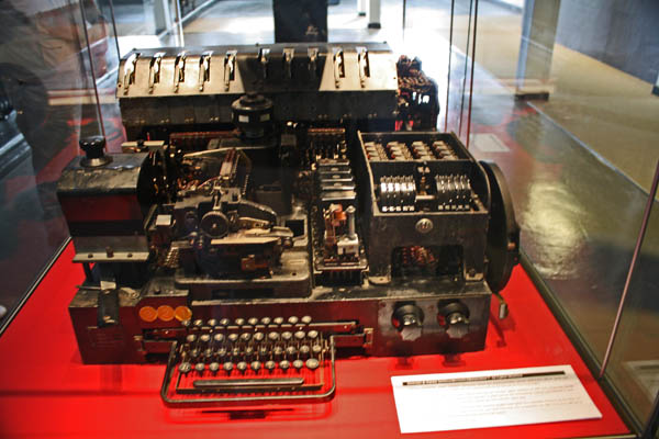
Not only did the mathemeticians work on deciphering the Enigma machines, but they also worked to decipher the coding of the Lorenz machines used by Hitler, the High Command and German Army commands throughout occupied Europe. The operator transmitted a clear twelve-letter indicator which told the receiving operator the exact rotor start positions. He entered all the 4000 characters only to be told by the receiving operator that he hadn’t got it. Assuming the system was unbreakable, the operator used the same settings and because it was standard procedure, sent the indicator again. Therein lay his mistake. He compounded the error by using abbreviations when he re-keyed the message, because the small differences were a great help to crypanalyst John Tiltman. It took Tiltman ten days but he recovered both German messages in full, thanks to the operator’s mistake.
As the Lorenz was more complicated than Enigma, to encrypt by hand was almost impossible. The British first developed an initial attempt called the Newmanry after Dr. Max Newman, but then they called on Post Office Engineer Tommy Flowers who designed the Colossus machine – that would read paper tape at 5000 characters per second. The Colossus machine would be the forerunner of today’s computers.
Another cypher machine that was used was the Siemens & Halske T52 Schlüsselfernschreibmaschine (SFM), codenamed Sturgeon by British cryptanalysists. The T52 was used by the German Naval units due to their weight, while the Army units used the Lorenz. The Bletchley Park Museum has a couple of these for viewing.
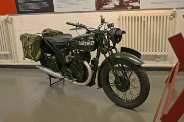
The Museum site is quite a large-sized area encompassing numerous blocks and huts that contained the various military and civilian divisions. Several of these huts worked as teams in order to more quickly process the encoded and deciphered information, sending it through translation and analysis, building up cards of information of people and places that were revealed and then relayed to the Command Centre in the mansion. One of the methods of transferring that information on the Park grounds was by motorcycle, such as the one below.
In 1992 the Bletchley Park Trust was set up to preserve the historic buildings, and has managed to save it and develop the site as museum with a wonderful educational program. The restoration of the site to its WWII era appearance will take about ten years and £20 million. The first phase of the project fundraising was completed at £7.4 million.
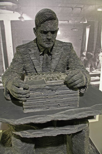
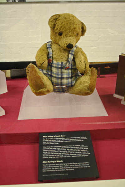
Inside Block B contains the largest collection of Enigma machines on public display. It also contains a large section on the contributions of Alan Turing to Bletchley Park and to the history of modern computer programming. During WWII, Turing worked for the Government Code and Cypher School (GC&CS) at Bletchley. The display includes old diaries, an old teddy bear, a detailed history of his accomplishments and his posthumous pardon, and an artfully sculpted slate statue of Alan Turing done by Stephen Kettle.
Over the span of World War II, the contributions of those working at Bletchley Park led to:
Location of the U-Boat packs in the Battle of the Atlantic
Identifying the beam guidance system for German bombers
The Mediterranean and North African campaigns, including El Alamein
Launch and success of Operation Overlord, including breaking German Secret Service Enigma, complementing the Double Cross operation which misled Germany on the intended target for D-Day
Helping to identify new weapons including German V weapons, jet aircraft, atomic research and new U-Boats
Analysts of the effect of the war on the German economy
Breaking Japanese codes
The outcome of the war in the Pacific.In addition to the images shown above, I was able to take a number of photographs around the complex campus of the museum grounds.
On the grounds there is this wonderful monument to the Polish mathematicians who’s assistance to Bletchley Park’s work during WWII was instrumental in helping win the war. Upon the monument is etched the following words (both in English and Polish – but for here, I’ll just type out the English).
“This plaque commemorates the work of Marian Rejewski, Jerzy Rozyckland, Henry K. Zygalski – mathematicians of the Polish Intelligence NCE Service in first breaking the Enigma code. Their work greatly assisted the Bletchley Park Code Breakers and contributed to the Allied victory in World War II.”
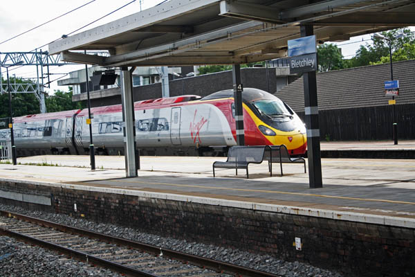
As we were leaving the Museum for the day, I was endlessly fascinated by the whole visit, but there was so much information to take in that I knew I wouldn’t remember it all, without reference to look back on. We headed back to the train station to wait for our train, which due to troubles on the line north of where our station was, we were delayed about an hour and a bit. Occasionally we’d just sit and wait as the Virgin Rail high speed trains went whizzing by (going from London to Manchester). We nicknamed it ‘The Virgin Bullet’. The first shot I took was a big blur, but putting it over to the automatic setting for Action, I did get a good shot of the train as it went through the station stop:
If you’ve never been to the Bletchley Park Museum, I highly recommend it. It is truly spectacular and will continue to be as it goes through its restoration process. It’s an absolutely stunning outing to explore. Check Opening Times for visiting information. Bletchley Park is open to visitors daily except 24, 25, 26 December and 1 January.
____________
Information for this post was provided by the Bletchley Park Museum website and the Bletchley Park: Home of the Codebreakers Guidebook, as well as YouTube for the video links.
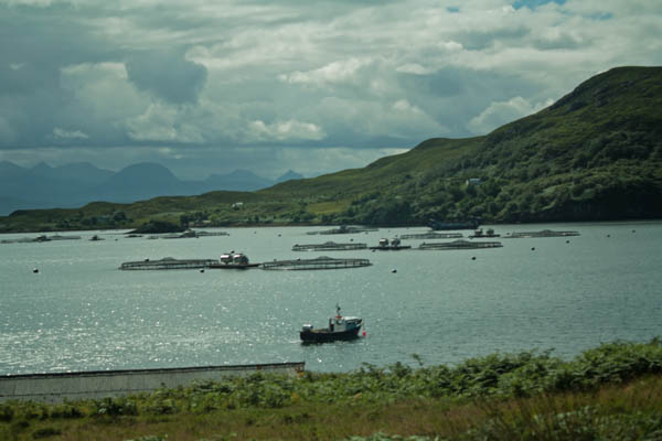
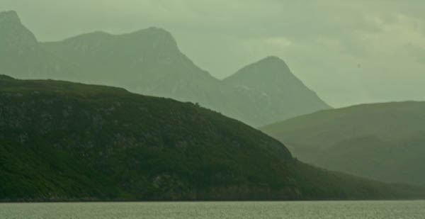
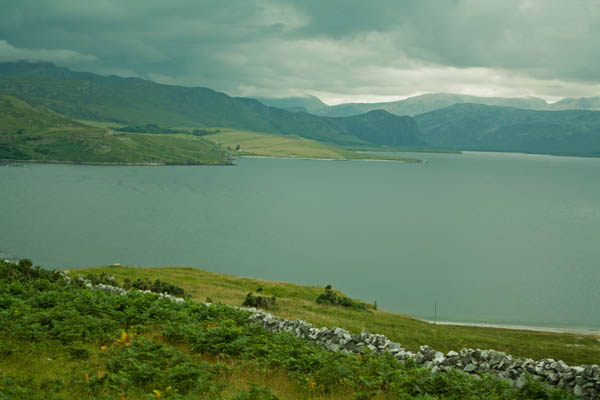
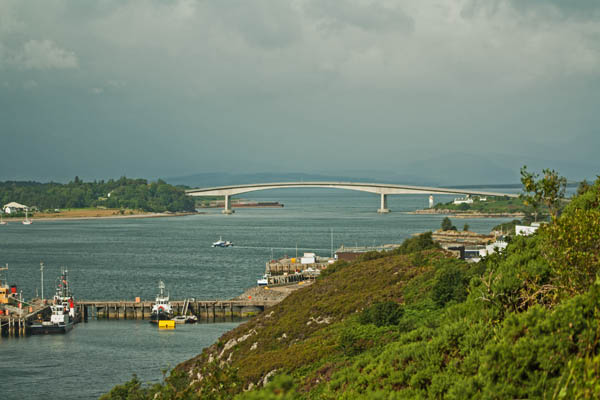
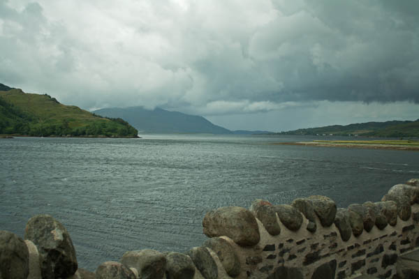
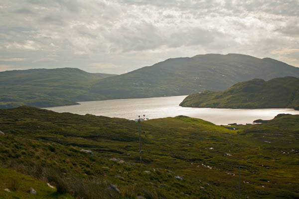
Today marked the final day of our tour through Scotland’s Outer Hebrides, as we left the Isle of Skye behind and moved back onto the Scottish mainland. Where we arrived in Uig by ferry a couple of days ago, today we were headed down the eastern road along the Inner Sound, passing by the islands of Rassay and Scalpay as we went towards the Skye Bridge over to the mainland.
The bridge connects over the sound between the villages of Kyle of Lochalsh on the mainland and Kyleakin on the island, and was built from 1992-1995 when it opened. There had been a toll on the bridge of £11.40 (return trips) for a short time before it was cancelled due to heavy protests that it was the most expensive road in Europe and non-payment by residents. In December 2004, the bridge was bought for £27 million and tolls immediately ceased. The image below shows the segment from Eilean Bàn (where there’s a support structure for the bridge between Skye and the mainland.
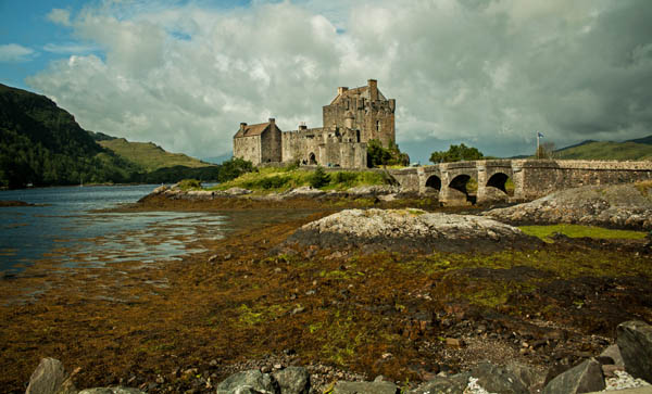
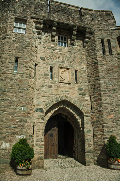
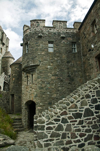
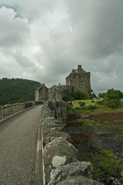
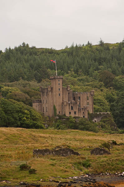
We drove down to Eilean Donan Castle, to visit and take photographs. I visited here when I was in the UK seven years earlier but it’s still pretty impressive. The castle is strategically situated at the head of three lochs – Loch Alsh, Loch Long and Loch Duich and was built as a defence against warring clans and nations. The original medieval structures were built in the thirteenth and fourteenth centuries. By the end of the 15th century, however, the castle had been reduced to 538 square metres. In the 16th century a hornwork was built with a hexagonal bastion and added to the east wall.
Like many castles in Scotland that were used as defences, such as Urquhart Castle, Eilean Donan Castle was destroyed in 1719 when it was bombarded by English ships against the Jacobite stronghold and Spanish soldiers who were helping the Jacobites. The castle sat in ruins for nearly two hundred years before being rebuilt by Major / Lt. Col. John McRae-Gilstrap and Farquhar MacRae over a twenty year period. Rumour has it that the architect had received the blue-prints of the original castle in a dream and devised the rebuilt castle from these plans, and when the original blueprints were found at Edinburgh Castle from a survey of the property just five years before its 1719 destruction, it was determined that the newer blueprints for the castle to be very close to the original. It cost £250,000 to build and was formally completed in 1932. The Billeting Room’s walls are 4.26 metres (14 feet) thick. Visitors are unable to take photographs inside, but if you’re interested, the official Eilean Donan Castle site offers a virtual tour through the grounds. The following are photographs I took on and around the castle grounds.
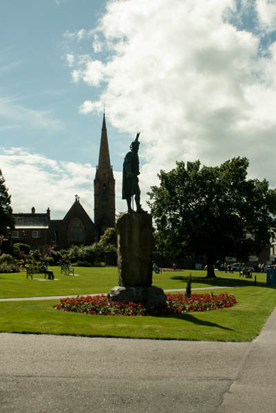
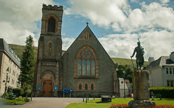
Before we left, I went into the gift shop to pick up a few things (music, a t-shirt, some postcards and stamps), and just as we were leaving, there was a little sprinkle of rain coming down, but it didn’t last too long as we moved further south-east and stopped in Fort William for a lunch break. Several of us went together to a pub that had some really good food before meeting up again in The Parade area in front of the Duncansburgh MacIntosh Parish of the Church of Scotland.
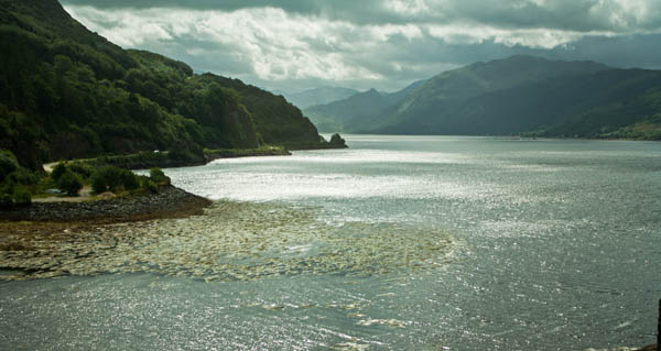
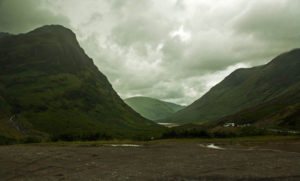
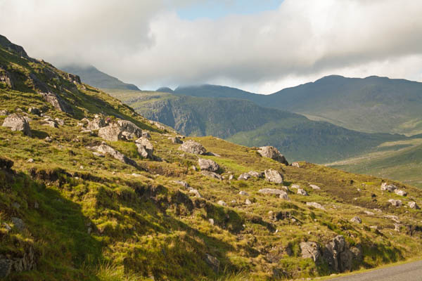
From here we returned to the area of Glencoe and Ballachulish that we’d passed through on the first day of our trip. I’d remarked, amusedly, that a friend of mine who lives in the area was actually visiting Canada at the same time I was visiting her hometown area.
The area shown in the pictures below are of Bidean nam Bian (The Three Sisters of Glen Coe) just south of Glencoe, are a part of three ridges that extend into the glen.
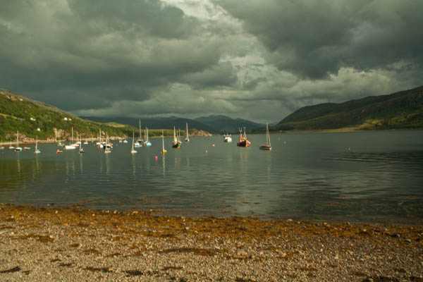
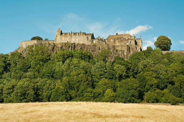
We stopped off for a little break as we headed down through the Trussochs and down to Stirling and as we went south the sun had come out and was really quite nice. We stopped not far from Stirling Castle to take some photos – from a different angle than from the long distance shot I took from the Wallace Monument ten days earlier. This was our final stop before heading back in to Edinburgh where we were being dropped off at Waverley Bridge. Thea, one of my trip companions, and I were staying in the same area but not the same hostel, so we headed to our respective places and agreed to meet up a little bit later to go grab some supper.
As usual for my trip – except for a couple stops – my accomodations had me on the third floor of a hostel. Old building, no elevator. Luggage. Anyway, as my train was to depart really early the next morning, they didn’t charge me the room deposit. They also pre-ordered a taxi ride for the morning to take me to the train station, which I gratefully appreciated. I deposited my stuff in the room I was staying and headed out to meet Thea. We had a wonderful dinner before we parted ways and I headed back to the hostel to get ready for bed and make sure all my stuff was packed.
The next morning came really early, as I mentioned, and it didn’t take me long to get dressed and carry all my stuff down three flights of stairs and drop my key off at the hostel office mail slot. The cab driver dropped me off at the platform level, and I’d forgotten about going up stairs to the main station offices to get the actual ticket – I had my payment confirmation slip with me, but at least the train operator let me stay on board…thankfully, since we were already past Edinburgh when he came round. I got into London about 11:30am-ish, then the Tube over to Victoria station and another train over to my cousin’s in Epsom. I was beat. But not too beat to go meet up with a friend in London that afternoon. 🙂
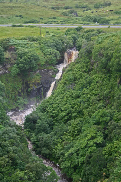
This morning we headed up the Trotternish (northeast) peninsula of Skye along the A855 towards Elishader. As the rain, wind and fog was approaching, the Old Man of Storr was not visible. One of these days, I’ll get to Skye on a sunny day (or at least less overcast) when I can actually see it as the last time I’d been on Skye (May 2006 was the last time). We stopped off at a viewing area in Lealt, near Kilt Rock, where a waterfall dropped heavily due to the increased rain flow. It was also very windy as we made our way over the slight path to take the photos. I had on this ‘waterproof’ camping poncho – not exactly the best thing to wear on the coast of Skye as the wind kept taking the edges and blowing it around like crazy – thus the rains that had started and coming at us somewhat sideways started the soaking of clothing.
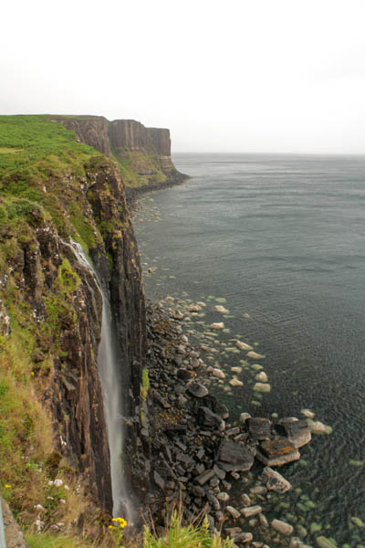
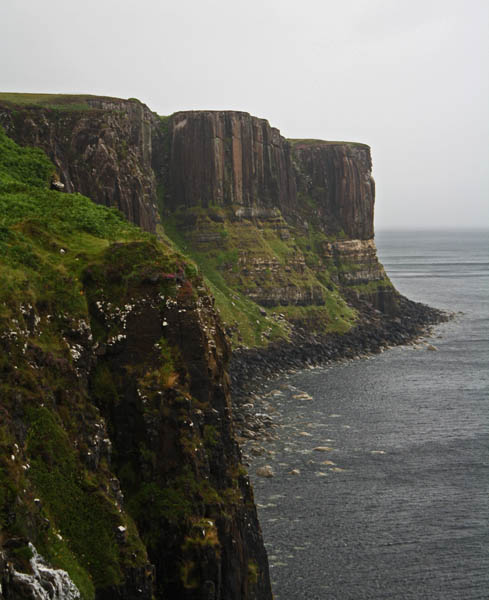
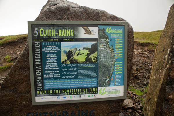
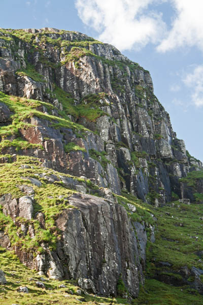
From there, we moved up the road to the Mealt Falls at Creag an Fhèilídh (Kilt Rock) near Elishader. The falls come from the overflow from Loch Mealt and drops 55 metres (180ft) over the sea cliffs. I’ve been here before, but it is nonetheless spectacular, even in overcast conditions. The rain had stopped at this point though it was still windy. Along the viewing area along the cliff edge, there’s a steel fencing that surrounds the outcropping and the winds blowing through the steel creating lovely music. It was wonderful. At various times with the heavy winds, the spray from the waterfall blew sideways as it poured down the cliffs. Looking further up the coast nearby were the cliffs of Kilt Rock. The dolorite columns of the cliffs form pleats that resemble the pleats of a kilt, lending to its name. The Creag an Fhèilídh is one of thirteen sites of the Ceumannan – Staffin Ecomuseum – a museum without walls – all the sites are out in nature to explore.
For the adventurous, climbers can actually repel and climb the cliffs of Kilt Rock. I’ve never learned how to do rock climbing but this looks like something I’d be willing to learn to try someday.
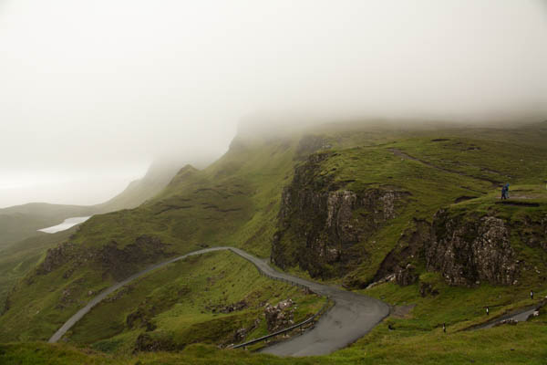
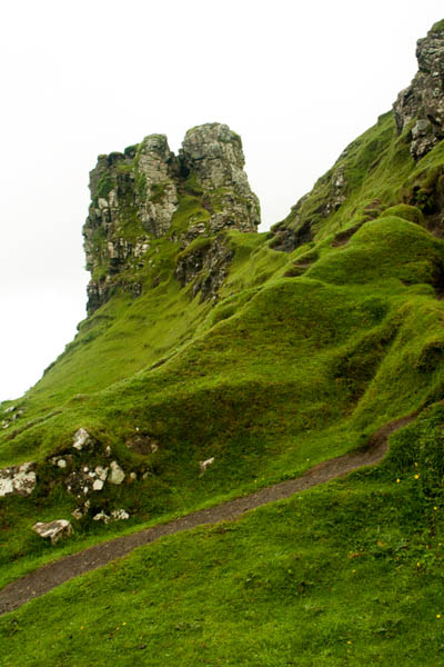
We moved further along the steep and sometimes hair-pin turn road to go visit the Cuith-Raing, or Quiraing, is on a landslip along the eastern side of Meall na Suiramach, northern-most summit of Trotternish Ridge. The geological theatre comprises several landmarks, of which only a few were actually visible due to the low-lying cloud and fog, and due to the heavy wind and rain, we weren’t actually out there long. That said, the views were beautifully dramatic.
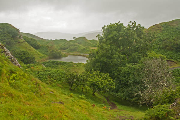
The next part of our trip took us to the Faerie Glen on the western side of the Trotternish peninsula, a little bit inland from Uig. I’d been here before as well, but it’s just absolutely stunning, even in the overcast setting. Though the last time I was here it was a fair bit less windy, so it made going to the top of the structure a little more tricky, and I ended up deciding not to do it this time – I’d been able to go up last time so there wasn’t as much of a goal to achieve, especially as the approach is really narrow…remember I said it was really windy? 🙂
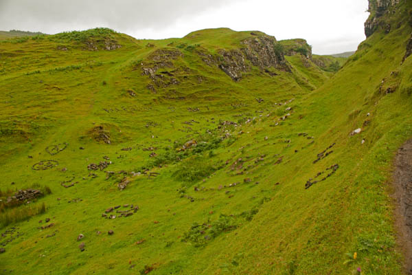
When you get to the faerie glen, you’ll notice that the hills and valleys are smaller here than their highland counterparts. It’s a beautiful hike through the hills. And if you so wish, you can throw down a few shiny coins into the stone circles on the hills – the faeries like shiny coins – but don’t throw down anything else; trash left brings bad luck.
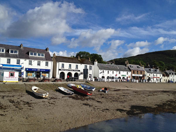
On our return to Portree, we passed by The MacLeod’s Table, two flat-topped hills, which we could scarcely see due to foggy conditions. We had a bit of a break so we returned back to Portree for some lunch, so a few of us went to the Portree Hotel’s dining room for some food then after I wandered around a few shops up on Bosville Terrace, picking up some more postcards, stamps and snack food. There were a few shops selling many different items of clothing – quite a bit of it with wool. They had these gorgeous Aaron knit sweaters which I would have loved to buy, but didn’t get for various reasons, but mainly because they were made of wool and as I’ve mentioned before, I can’t wear wool (unless I’ve got long sleeve turtleneck shirts on underneath). Also, my mum knits and has made me a couple of Aaron knit cable sweaters made with acrylic yarn, and thirdly, I was running out of space in my suitcase. However, I did find a nice waterproof jacket, which I did need – and folded up fairly small when not in use – on sale for £30, so I did get that – and put it right on as it had started to lightly rain again. I quickly made my way back to the bus terminal where our bus was parked and was taking us off on our afternoon adventure. Not everyone was coming along that afternoon though as some had been on Skye on the first leg of their tours the week before.
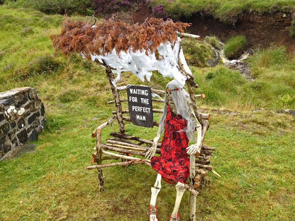
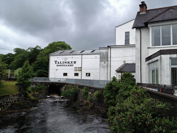
We continued for a drive in the afternoon up towards where our tour guide went through school and where he grew up. The scenery was quite beautiful. It was overcast and occasionally sprinkling with rain, then we popped into the Talisker Whiskey Distillery, where I picked up a couple of small bottles of Scotch to bring up to my father. And we happened upon a few scarecrows that were part of the Tattie Bogal Scarecrow Festival. The one below was one of my favourites.
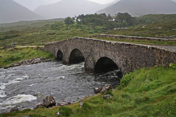
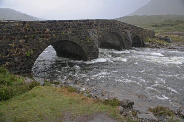
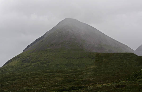
We drove on a little longer through Dunvegan and down through and stopped off at the Sligachan Hotel and headed over to the Sligachan Bridge, with the river heavy with rain rushing through the arches. The nearby Cuillin mountains nearby provided a lovely backdrop. I wish it hadn’t started raining but there was some wonderful shots to be taken. According to legend, the Cuillin take their name from the Gaelic hero, Cúchulainn, although this is probably a folk etymology. Legend has it that Cúchulainn learned martial arts from the warrior woman, Scáthach, who was said to have a fighting school in Skye. She bested him in a fight and so after learning from her, he challenged her once more to a fight and won. (ref. Tour guide’s local knowledge, along with Wikipedia reference and– The Cuillin History & the Peak Names
We headed back up to Portree for the night. I stopped off at the hostel where they’d moved me into a four bed female dorm. I hung up my wet clothes and changed before heading up to The Co-operative Supermarket for a few things, then up to the Bosville Hotel restaurant for supper. Some of my tour mates had gone there the evening before and had recommended the place, so I decided to take them up on it and I’m glad I did – fantastic meal and dessert – and grateful for the time I went, as shortly after there was quite a queue for seating. I headed back to the hostel and relaxed for a while, got showered and dressed for bed before writing up some more postcards. I listened to a couple of BBC Radio4 podcasts before falling asleep.
Today we left the flatter hills of Lewis for the more mountainous area of Harris, as we ventured southwards in order to catch the ferry over to Skye in the afternoon. It was fairly barren, given the landscape, but quite beautiful.
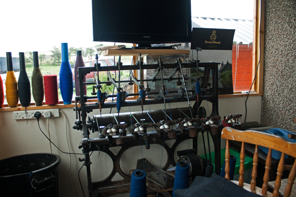
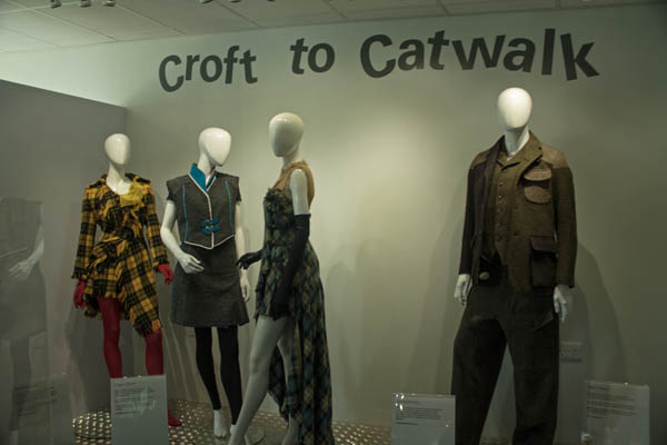
We stopped off at the newly opened Harris Tweed Centre in Drinishader, Harris, where you could see an exhibition on how the process is making tweed from the initial stages of getting pure virgin wool to the mills where it is dyed according to requested colours to the spinning of the wool onto spools and spun into cloth in the weaver’s homes then returned to the mills for finishing. To get an idea of the process of how tweed is made, the Harris Tweed Authority demonstrates this in a 4-part series of posts on their blog: How to Make Harris Tweed. It’s really quite fascinating if you really like crafting as it is a detailed but fascinating process.
We browsed through the shop at the various items from tweed iPhone covers to hats, jackets, and various other things made with Tweed. Looks wonderful, alas, I can’t wear wool such as a sweater or jacket unless it’s fully lined and I’ve got a cotton long-sleeve turtleneck on. Mum’s the only one in the family that can wear wool.
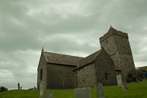
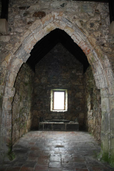
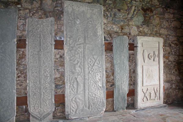
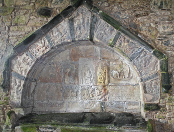
After this we headed south to Rodel in the south end of Harris to see Tùr Chliamainn (St. Clement’s Church), a fifteenth century church that had been built for the Chiefs of the Clan MacLeod of Harris. There are two chapels on either side of the main hall, and the rear of the church, there’s a tower that you could go up along to a small room. The high winds could be heard loudly as you went up the tour and the overcast skies made for an eerie atmosphere.
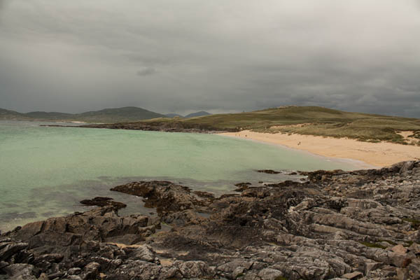
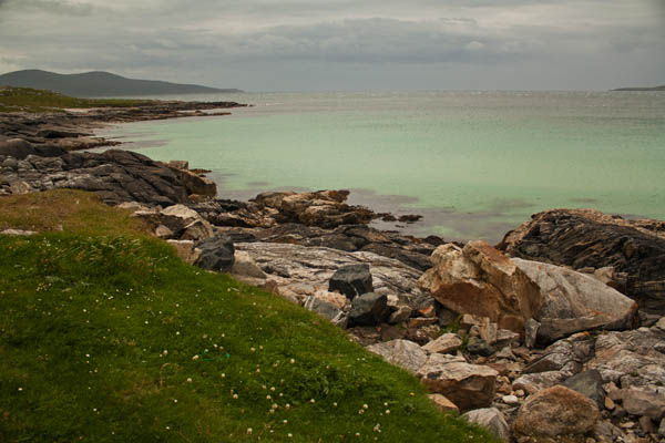
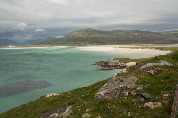
After a while, we headed up a little to have lunch at The Anchorage Restaurant in Leverburgh, over-looking a lovely bay. We then drove up the western coast of the lower end of Harris, heading back to the Port of Tarbert where we were to catch the ferry over to the Isle of Skye. Along the way we stopped at for a couple photo opportunities on the A859, overlooking gorgeous beaches with soft sands and shallow turquoise waters of the Atlantic Ocean.
On the ride over to Skye, the winds were up and so were the waves. I found a place to sit down, and watch a bit of tele that was running a few episodes of “Midsomer Murders”, though at some point I fell asleep and woke shortly before we were to disembark the ferry as we arrived in Uist on the Isle of Skye and from there we made our way to Portree where we were staying for two nights. There was a minor quibble when we got to the hostel in that they couldn’t find my reservation, but they were able set up an extra mattress in one of the dorm rooms. Anyway, I got my stuff sorted for the time being and headed out to wander the streets of Portree. Given that my computer was down I was happy to find a shop that had some books to buy. I found a copy of Denise Mina’s “Still Midnight”; I couldn’t remember if I had a copy of it at home (ETA: I do), but I hadn’t read it yet, so I picked up a copy to read. I stopped round the Cooperative supermarket to pick up some cereal for the next two mornings, some fruit and soft drinks before heading for food for supper.
It was still mostly overcast, but as I was headed down to the pier to get some supper from the Fish & Chips shop, it had started to clear off a little. I took this shot down at the pier and took my take-away back to the hostel. I finished my tea and got ready for bed, curled up on the mattress and read for a little while before turning in for the night.
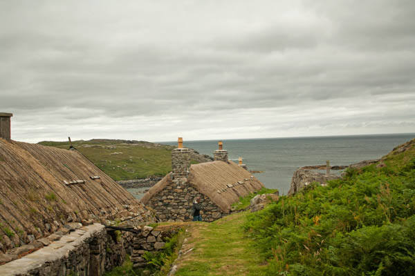
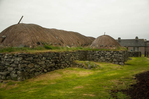
Today, we headed out in the direction of the Arnol to see the Blackhouses. The Blackhouse provided an insight into what island life may have been like up to 150 years ago up until the early 1970s. The roofs are thatched with cereal straw over turf and then weighted down with large stones tied down each side of the roof.
I managed to set the camera down and get a lovely shot of the peat fire that was burning on the floor in the centre of the blackhouse. As there are no chimneys in the blockhouses, it’s the burning peat that gives the houses it’s name because the soot from the peat fire coats the interior of the homes, and smoke escaped through the roof. The houses not only held residence for people but also domestic animals and livestock. As we were in there for some time, the smell from the peat fire clung to my clothing. It was quite a nice smelling earthy scent. Outside, there was a pile of peat drying in order to burn later.
Our tour guide next took us to Carloway Harris Tweeds, to a local weaver of Harris Tweed, Norman MacKenzie. His specialty is working with single width (60cm / 24in), and doing more customized weaving, compared with some of the other weavers hired by the mills that use double width (120cm / 48in). While I was looking up some information on the weaving, I actually found a YouTube video of the weaver we visited. It was really interesting seeing how he stretched out the yarn to be put on the warps and the shuttle (or weft) and then how the yarn was woven on the loom. It’s all hand-woven, human powered weaving. Authentic Harris Tweed to be officially designated as such, must be woven in the Outer Hebrides of Lewis and Harris, must be pure wool and must be woven in people’s homes. The tweed and the process is regulated by The Harris Tweed Authority – Ùghdarras a Chlò Hearaich (Guardians of the Orb).
We then headed up to a Gearrannan Baile-Tughaidh Blackhouse Village where they’ve got blackhouses that had been converted inside and are being used for vacation spots. It looked amazing and something I’d love to try some day to stay for a visit. There are four cottages; one sleeps 2, two that sleep 4-5, and one that sleeps up to 14.
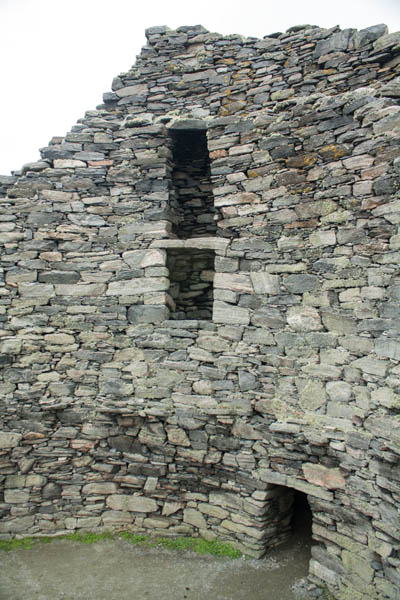
Continuing on our adventures, we headed over to the Doune Broch Centre (Ionad an Dùin Mhòir), then up to the Broch itself. The Iron-age broch dominates the crofting village of Dùn Charlabhaigh (Dun Carloway) and it’s one of the largest and best preserved brochs, built sometime around the first century BC, with radiocarbon dating of some remnants within the broch showing it was probably last occupied in 1300 AD. The east wall is 9 metres high and about 14-15 metres in diameter at the base. Like the blackhouses, the brochs also housed people and animals. Because of its position high up on the hill, it provided a great defensive location and had still been used as a defence between disputing clans.
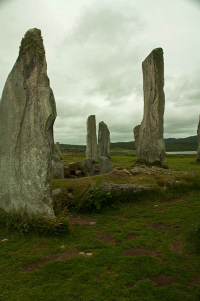
Our next stop of the day was to go see the Calanais Standing Stones. These standing stones here have a smaller circular ritual placement with four length extensions from that centre outward. It is symmetrical, running true east-west; the western half being a true semi-circle but the eastern half is flattened. Construction of the site dates back between 2900 and 2600 BC. There are also two secondary Calanais standing stones sites not far from the main set of stones.
The Uig Chessmenrefers to a Viking chess set discovered on one of the sandy beaches in a small stone chamber, and were made probably around the 12th century. There are pieces held in the National Museum of Scotland in Edinburgh, the British Museum in London, and at the Stornoway Museum. This statue of the King remains at near one of the Uig beaches.
Also near the beach was a hilly field with some highland cattle, including a russet one and a black one. And my final pic of the day was a pretty purple wild flower that a few of us found on the way back to the bus.
We made our way back to Stornoway where we spent our second night, and Thea (one of the women on our tour who was staying at the same B&B that I was) and myself went to supper at the dining hall of one of the local hotels, for a wonderful meal before returning to our Bed & Breakfast after a stop at Tesco’s, which was on the way.
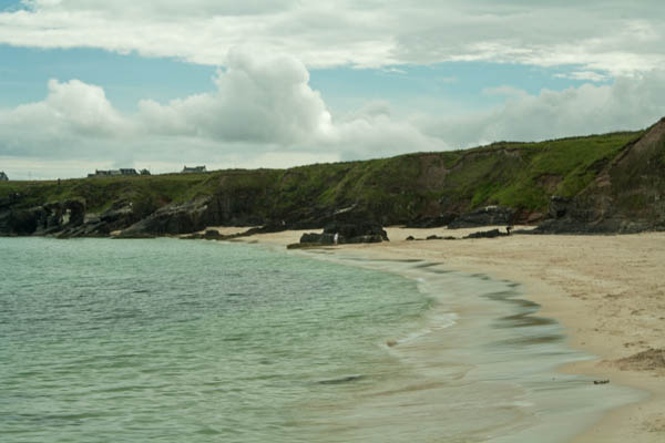
We left Ullapool in the morning on the ferry to head over to Stornoway on the Isle of Lewis. It was a two hour plus ferry run, so after writing up a few postcards, I put stuff away and curled up on the large cushions and fell asleep. When I woke, it was close to the time to head down to our Rabbie’s bus, so I gathered my backpack and camera bag and met up with the others in the lounge and headed down to the vehicle deck. Once in Stornoway, we got a brief run around to see where things were before parking at a bus terminal and getting out to explore a bit and grab some lunch. Afterwards we were back on the bus, heading west then north up to the Port of Ness. As we travelled along, we could see at various points along the flatter lands of Lewis, long strips out of the land where they were digging up peat to be dried out and then used as fuel. When we got to the Port of Ness, we stopped off at the beach there to the lovely soft sands; the water was turquoise with the underlying sand and shallow waters.
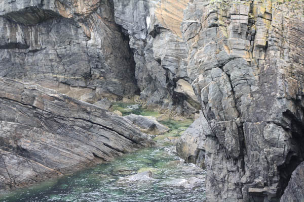
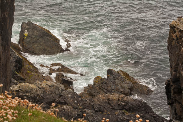
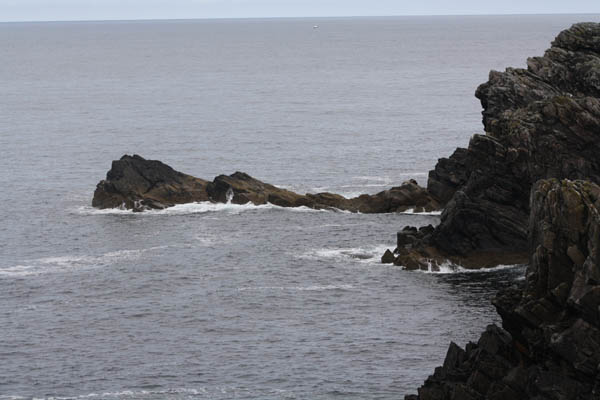
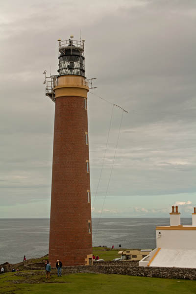
When we left there we headed up to the lighthouse at the Butt of Lewis. While we were up there, there was a bit of a flurry as a small pod of dolphins that kept surfacing, however briefly. I did manage to get one photo off of a dolphin’s dorsal fin but it turned out quite blurry. That said, the surrounding area with rugged coast was really quite beautiful.
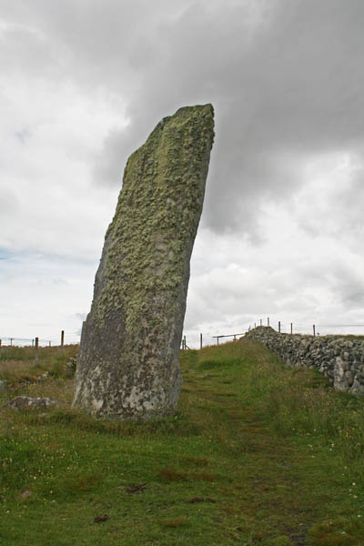
As we made our way around the north end of Lewis, we noted some other standing stones around the island in seeming random places, including those incorporated into crofts on the lands. We drove up to one on a side street where there was one that had been incorporated alongside someone’s garden.
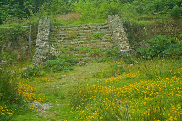
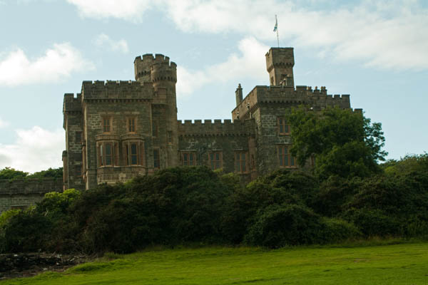
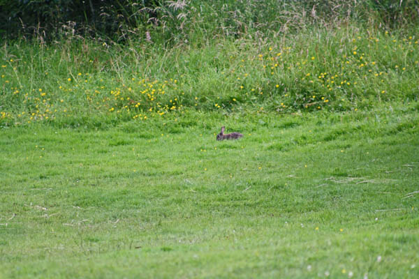
While it was quite overcast in the north part of Lewis, when we returned to Stornoway, the weather was starting to improve and we shown to a few more restaurants in the area then we were dropped off at our respective accommodations. Here I was actually staying at a Guest House, and one of my tour companions, Thea was also staying at the same place, so we decided to take a walk, which wasn’t too far to the Lewis Castle – which is now part of the University of the Highlands and Islands. The castle itself is now being renovated, so there’s a big chain link fence around it. There was a beautiful path on the way up to the castle. There were quite a few rabbits around, too, and I finally managed a good pic of one that didn’t skitter off too far, but needed the telephoto lens.
We wandered back to the downtown core on our way to find a bite to eat, a local passerby gave us directions to a spot for a good meal, so we popped round to Eleven at Caladh Inn, and had a wonderful supper, so much so that we were planning to return the next night for supper. Given that our Guest House wasn’t far, we walked back after a quick stop round to Tesco’s to pick up a thing or two. I worked a while on my computer before it decided to stop working. Mild panic. Up in the Scottish north with my MacBook not working and not exactly a spot to have it easily looked at to see what’s wrong. So, I decided to work on some more postcards and watch a bit of tele until I fell asleep.
Today I had a free day, so while I was out the night before on my way back to supper, I picked up a couple tourist pamphlets down at the dock for days out adventures. It was a nice sunny day with a few clouds, so I left the hostel and headed down to the pier – which given that the hostel was right across the street from the stone beach. Two of my travel companions from the tour – Thea and Wade – were also going on the same boat ride out to the Summer Islands that I was going on, which was nice. While we were waiting for the boat to disembark, I took the chance to take a couple of shots.
When we got back to the dock, it was almost 2pm and the hostel wasn’t going to be open until 4pm (they close between 10am – 4pm each day for cleaning, so I wandered about a bit to the post office to mail off a few postcards, and then found a tea shop and stopped off for some soup and a biscuit, and read for a while before heading back to the hostel’s quiet room until they officially reopened. As the afternoon got later, I looked out the window just before the rain was going to start and saw this beautiful view.
It was a quiet evening, I headed up the road a bit to a tourist shop to pick up a new umbrella – my other one got left somewhere – and then further up the road to the Ferry Boat Inn (FBI) pub for delicious supper and interesting chat up at the bar with a couple from Australia. When I got back, I went and got a shower and ready for the night, so that I wouldn’t have to cue for the showers in the morning. Got my devices charged up and headed to bed. I was joining the Outer Hebrides Tour in the morning.
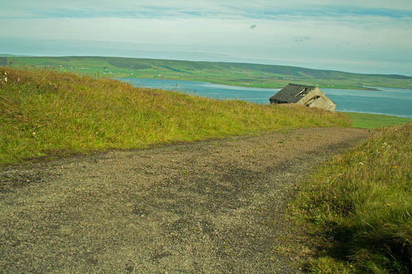
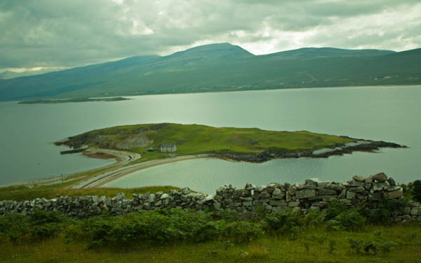
Today, 29th July, aka my 40th birthday, was the whole reason I planned this whole trip to the UK, and I have to say it’s been one of the best birthdays I’ve had. The plan for today’s part of the tour involved us making our way from Orkney and heading back to the mainland, our final destination of the day was going to be Ullapool, as we crossed over the north coast of Scotland. After the soaking wet day of yesterday, we had a gloriously sunny day to start. We were picked up from our accommodations and headed up to the highpoint of the Orkney mainland to the Orkneying Saga Trail on Wideford Hill. From here, you could pretty much see the surrounding area to all sides. This is one of my favourite views.
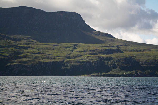
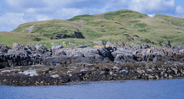
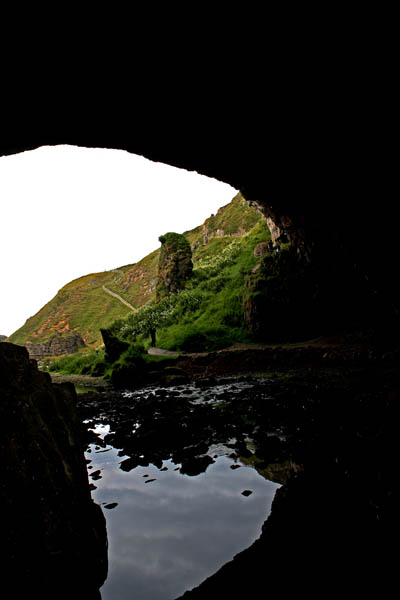
It was a lovely day to cross the North Sea back to the mainland, and although it was breezy the ferry ride was actually fairly a smooth run. When we got into the dock, alongside the docking port, there was an outcropping of rocks on the right hand side where a couple of seals were relaxing.
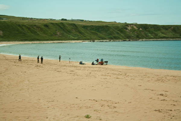
We travelled along the A836 along the north coast, around various ports and bays with gorgeous scenery before stopping in Thurso to pick up a picnic lunch at the Tesco’s and then headed further west to Melvich Bay (I think) to have lunch on the beach. Such soft sand and lovely to walk on barefoot.
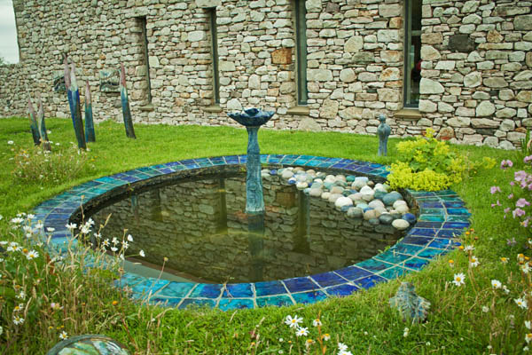
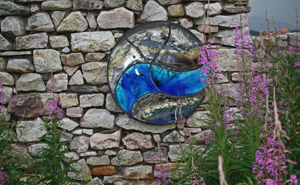
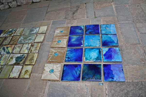
After our break, we continued along the A836 and A838 on the north and west coast, headed towards Ullapool. One of the places we stopped off to see was the ceramic artist, Lotte Glob’s Studio Croft. There we saw some some really neat sculptures and tiles of many different colours.
There was some absolutely stunning scenery coming down this area – though if I had to keep saying that, we’d be here all day. We stopped at a couple of places for photo opportunities before continuing on to the Cocoa Mountain at the Balnakeil Craft Village in Durness for some lovely hot chocolate, and where I picked up some chocolate presents for friends.
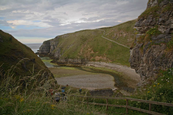
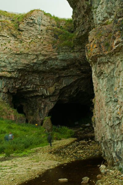
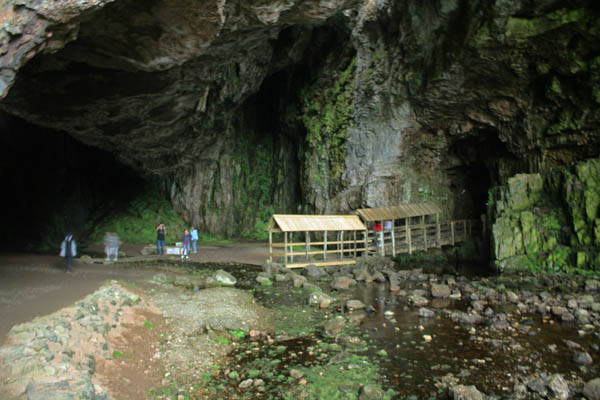
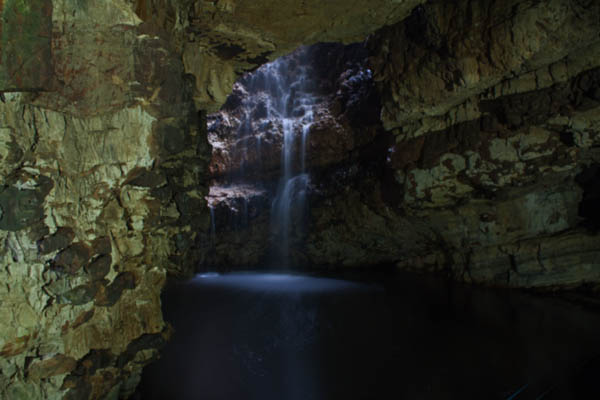
After this, we briefly doubled back a short distance to Smoo Cave, at the end of a 600m tidal gorge set into limestone cliffs, the waterfall inside drops in from a sinkhole. This is quite an interesting cave in that the initial part – further out into the gorge which collapsed due to erosion over the years – by the sea. The inner chambers of the cave, are formed by freshwater passages. There are three chambers to the cave – the first entrance into the cave is the outer chamber and a covered path leads towards the second chamber, where the waterfall empties into, and the furthest, the third chamber, is accessible by boat. The waterfall drops from an 25-metre (82ft) high point where the Allt Smoo falls through the sinkhole. I can still hardly believe that I got as good a shot of the waterfall as I did as it was quite dark in the cave. So what I did, since I didn’t have a tripod with me, was set the aperture and focus point with a long exposure, and the ISO level down to 100, and then put it on a 10-second timer and took the shot. I have to say, I’m extremely happy with how it turned out (fourth photo down, below).
Just we we were leaving the cave behind and Durness, it started to rain again, where it continued periodically through the area, and through the evening, as we pulled into our accommodations. I was actually staying on here two nights as I was leaving the the Orkney & The North Highlands Tour and picking up the Outer Hebrides Tour on the 31st. There were three others from the tour that were also continuing on with me while the rest of the group were returning to Edinburgh the next day (30th). Once I got settled with my things in the hostel, I headed over to the Seaforth Bar Restaurant Takeaway to join my travel companions for supper. Some of us ate inside and some outside under the canopy, and lots of laughter was shared…and then they brought me out a slice of birthday cake with a lit candle. More laughter to be shared. It was a good night, and then I headed back to the hostel to head to get ready for bed, do a bit of web searching, and then head to bed for the night.
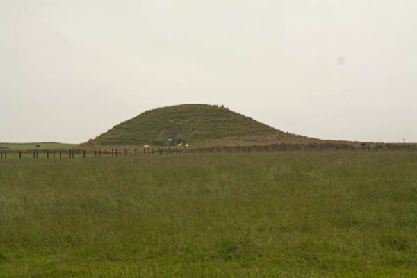
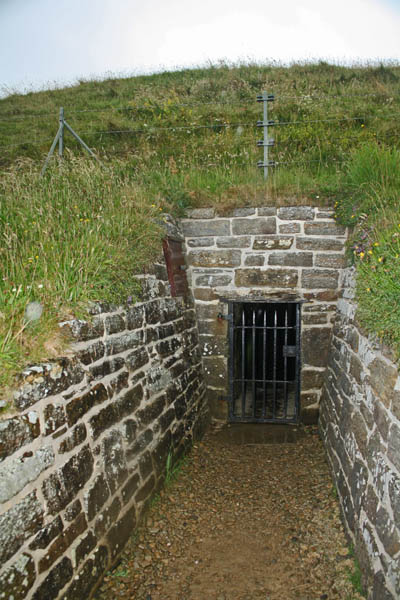
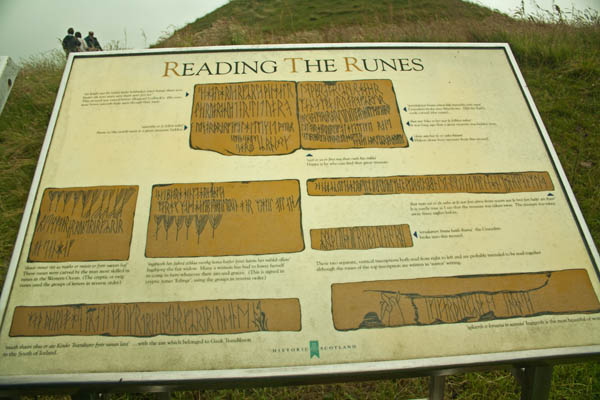
Today we set out to explore Neolithic Orkney, World Heritage sites that date back between 5100 to 3500 years ago. We visited Maeshowe chambered tomb, the Ring of Brodgar, Skara Brae, the Ness of Brodgar, and The Stones of Stenness. Inside Maeshowe, you could see the ancient Norse rune markings on the walls of the stone. The Scottish government offers a Virtual Tour of Maeshowe, wherein on the winter solstice, the sun sets in between the mountains and shone in through the 10 metre pathway to the chamber and the back wall. The mound is 35 metres in diameter and 7 metres in height. Visitors are not allowed to take photos inside, but I have a few exterior shots.
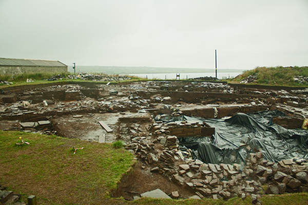
By the time we left Maeshowe, the wind and rain had picked up as we headed back to the bus to go to our next destination – the Ness of Brodgar excavations. In 2002, a geological survey of the area revealed a 2.5 hectare area that may have been indicative of a settlement. The excavations over the years since – done over a six week period each summer – has revealed settlements that have undergone radiocarbon dating to civilizations between 3200-2300BC. The site is currently only about 10% excavated at this point. The images that follow are of different sections of the excavation.
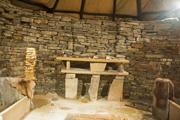
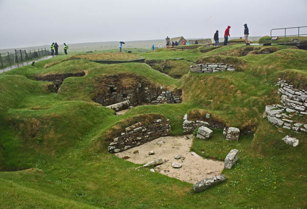
We then moved on to Skara Brae and the Skaill House. After getting some lunch at the visitor information centre and the exhibition displays, I headed out to the Skara Brae site; first to the replica house where it gave an idea to the internal structure of the homes, and then on to the actual site of one of the best preserved prehistoric villages (dating to 3100 to 2600 BC). These structures were preserved under sand until a severe storm in 1850 that revealed part of the structures, then excavations began. In the 1920s a protective seawall was erected to prevent further erosion of the historic settlements by the sea; it has been re-fortified over the years.
I didn’t get over to the Skaill House as the wind was up and it was pouring rain, sideways, and I was absolutely soaked so I just headed over back to the bus. We also stopped further up along the bay where a few got out to explore and see some puffins. Seeing a few of the pictures from the others, I kind of wished I had gone but I was also glad to have a bit of reprieve from the rain. By the time we got to our next destination, the Broch of Gurness, the rain had eased off somewhat, even though the wind was still up. On the plus side it helped to dry my jeans out a little. 🙂
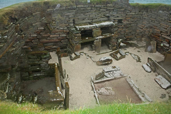
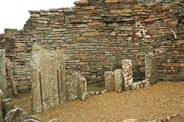
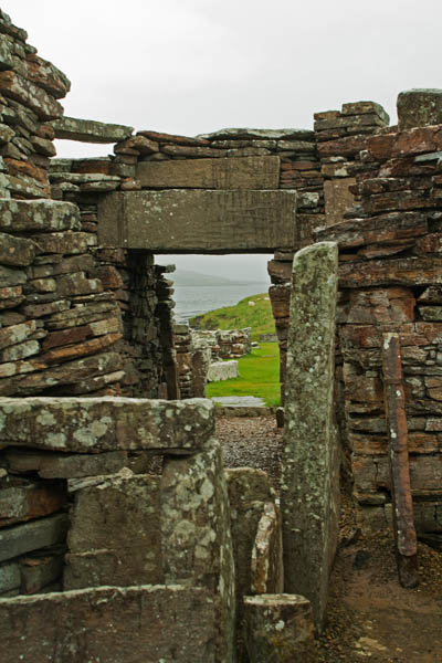
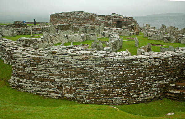
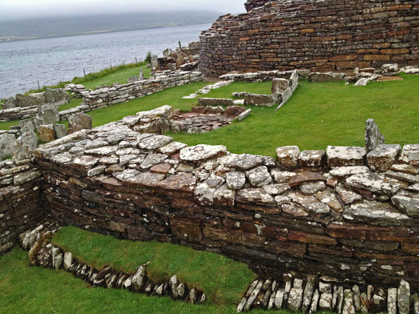
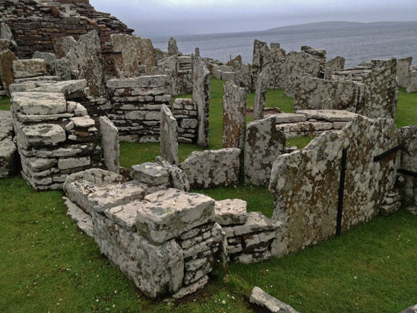
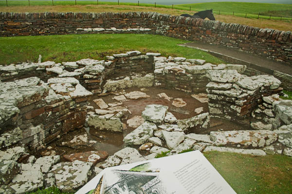
The Broch of Gurness village is dated around 500 to 200 BC and is one of the best examples of an Iron-Age settlement in northern Scotland. We were able to wander around the settlement much easier than that of Skara Brae, and thus could see more clearly the areas of housing.
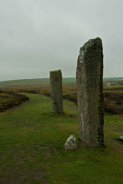
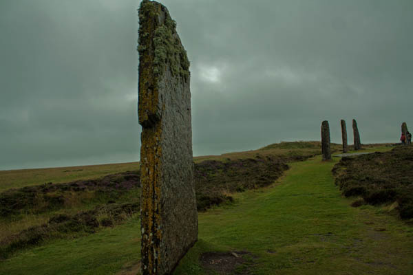
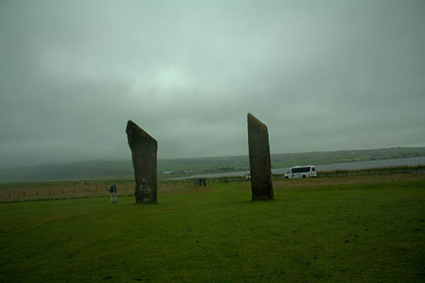
On our trails of viewing the heart of Neolithic Orkney, we stopped at The Ring of Brodgar, built relatively between 2500 BC and 2000 BC. The overcast day added to the mystery and ambiance of the scene in front of us. There are twenty-seven of a possible sixty stones survive around the circumference of the henge. Following that, we moved over to The Standing Stones of Stenness, which radiocarbon dating has set the building time around 3100 BC.
The Stones of Stenness was our last stop on the day’s itinerary before we headed back to Kirkwall. As I had leftovers from my Indian meal the night before back at the hostel, I decided to get dropped back to the Tesco’s near the hostel where I picked up some fruit and drink for the next day and a new pair of dry jeans. It hard started to sprinkle with rain again as I left Tesco’s but fortunately it wasn’t far back to the hostel. After getting in and hanging up my clothes on the heated towel rack and the radiator (which I turned up for the evening), I grabbed a nice hot shower then put on my pyjamas, got my supper then retired to my room to write up some postcards and work on my computer before retiring for the night.


![The Arnol Blackhouse, Arnol, Isle of Lewis. © J. Lynn Stapleton, 1st August 2013[/caption]](https://jlstapletonphotography.me/wp-content/uploads/2013/08/arnolblackhouse04_copy.jpg)